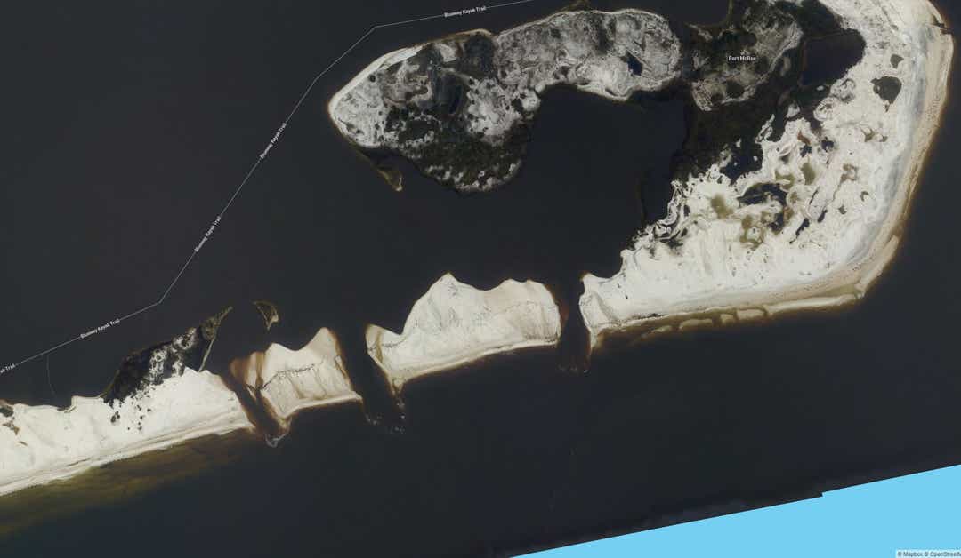
Hurricane Sally gouged three breaches into the eastern tip of Perdido Key, separating the isolated stretch of barrier island into three small islands.
The impacted area is undeveloped, sandy shoreline east of Johnson Beach and just south of Robertson Island. Even before the hurricane, the region was inaccessible by road and was primarily used by hikers and boaters as a recreation spot for camping, kayaking and swimming.
The three new channels created by Sally may make the farthest corner of the island even more remote.
More: 'There was water all the way across': Perdido Key flooded from both directions during Sally
More: Perdido Key man's drone footage show Hurricane Sally's devastation in Pensacola
The impacted area is part of the Gulf Islands National Seashore, and Park Superintendent Dan Brown said it was not the first time this has happened.
"Perdido Key has been breached in the past in about the same areas," Brown said. "That section of the island is extremely low lying and very narrow. That's why it was so readily breached. Fortunately, Fort Pickens was not breached this time. Hurricane Ivan breached Fort Pickens, a section about a quart-mile wide, but it was able to heal itself."
Brown said he had doubts a similar natural recovery will occur in Perdido Key.
"The (beaches) are so close to Pensacola Pass, and the longshore currents trend from the east to the west, so any sand that would be naturally transported would be between Pensacola Pass and those breaches," Brown said. "That's a very short stretch of the island, so there's probably not sufficient sand available for natural processes to heal those breaches."
How the government is responding
While the National Park Services does sometimes conduct dredging projects for the purposes of beach renourishment, Brown said their approach is typically to let nature take its course.
More: Grande Lagoon neighborhood hit by Sally struggles in aftermath of powerful storm surge
"When we stand and look out at the Grand Canyon, we don't see it as an erosion problem," Brown said. "It's just natural processes, and barrier islands both accrete sand — sometimes areas get built up and new land is created by the movement of sand — and sometimes areas get eroded. All of that change in the natural shoreline is something that is ongoing and constant, and typically when something occurs naturally through natural processes, we don't intervene."
Wade Jeffrey, director of Reubin O'D. Askew Institute of Multidisciplinary Studies at the University of West Florida, said barrier islands are dynamic, and that they grow and change over time almost like living organisms.
"Sand builds up in places and erodes in other places, and you get thin spots and heavy spots," Jeffery said. "Then, when you get storm activity, you get wash out through the low spots, and once the water starts moving through it, it just keeps moving sand more and more and it's eventually going to lead to the blowouts like you see in the pictures from Perdido."
Brown said the National Park Services hadn't had the opportunity to review the breaches from the ground. Currently, the service is still focused on assessing the impacts to its facilities and along roads like Highway 399 and Fort Pickens Road. He said after some of those assessments are complete, the Park Service would have further discussion on what, if any, action to take on the breaches.
Kevin Robinson can be reached at krobinson4@pnj.com or 850-435-8527.
tinyurlis.gdu.nuclck.ruulvis.netshrtco.de
مقالات مشابه
- Escambia County تعلیق اهل بیت جاده خدمه پس از عملیات تست مثبت برای COVID-19
- شرکت صادرات و واردات کالاهای مختلف از جمله کاشی و سرامیک و ارائه دهنده خدمات ترانزیت و بارگیری دریایی و ریلی و ترخیص کالا برای کشورهای مختلف از جمله روسیه و کشورهای حوزه cis و سایر نقاط جهان - بازرگانی علی قانعی
- ECSO: مرد پس از دستگیری نمایندگان راه رفتن به اتاق خواب و پیدا کردن باز کردن لپ تاپ با کودک رابطه
- غیر قابل قبول تضاد منافع باید خنثی دانشکده سنا رای گیری در سرمایه گذاری
- دانلود بهترین کتاب های رایگان آنلاین!
- مکان مناسب برای راه اندازی رستوران سنتی
- ده راههای جذاب برای بهبود استخر بادی مهارتهای شما
- سیستم جدید در اقیانوس اطلس به احتمال 50 درصد برای توسعه است اما این انتظار نمی رود به تاثیر زمین
- نکاتی مهم در مورد خرید باکس گل و شکلات
- الماس تراشکاری بهراد صنعت پارس وارد کننده الماس تراشکاری