Two tropical storms are expected to enter the Gulf of Mexico in the coming days, but forecasters say it's still too early to know exactly what that will mean for the Pensacola area.
Tropical Storm Marco formed Friday night over the northwestern Caribbean Sea and is forecast to move near the Yucatan Peninsula Saturday, joining Tropical Storm Laura, which is nearing the Dominican Republic.
Both storms are forecast to strike the U.S. within a day of each other, forecasters said. Marco's path is heading toward Texas, while Laura's path has moved away from Florida and toward Louisiana, Mississippi, and Alabama.
Track the path: Will Tropical Storm Laura impact Pensacola? Track the storm with these spaghetti models.
Twin systems: Tropical Storms Laura, Marco form potential double threat to Gulf Coast: What we know
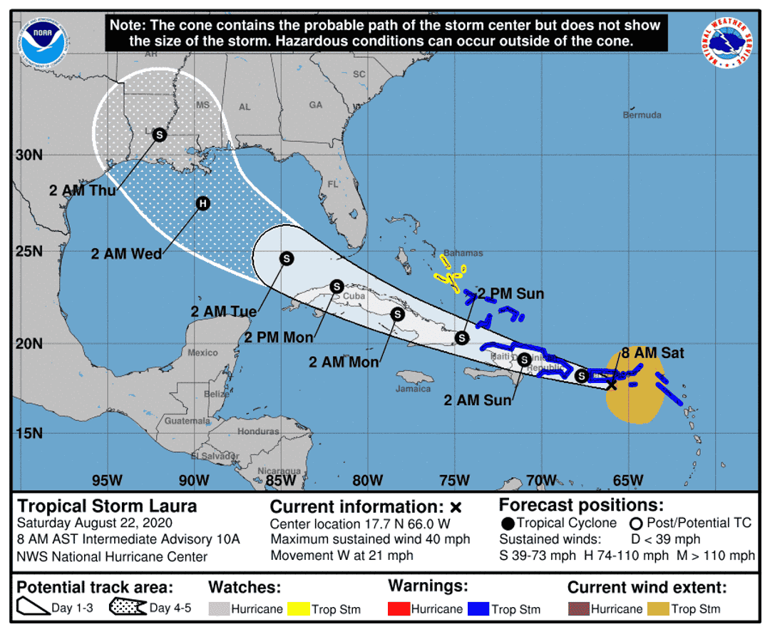
Tropical Storm Laura's path remains uncertain
Tropical Storm Laura remains disorganized, and forecasters say there is still a lot of uncertainty in the forecast, especially regarding intensity.
The storm's forecast path has shifted farther west overnight Friday, placing the Panhandle just outside the cone of its probable path, though impacts often occur well outside the cone.
Forecasters also caution conditions can change quickly, particularly as Laura's track and intensity are more uncertain than usual as the storm moves over the Greater Antilles through Monday.
At 7 a.m., Laura was about 50 miles south of San Juan, Puerto Rico, with maximum sustained winds of 40 mph, moving west at 21 mph, according to the National Hurricane Center.
The storm is forecast to approach the north central Gulf on Wednesday, potentially as a hurricane.
Tropical Storm Laura brings high rip current risk, rain next week
Regardless of the intensity of Laura, increased rainfall is looking likely into next week, according to the National Weather Service in Mobile, Alabama.
Rainfall totals over the next week could approach 5 to 7 inches along the coast
with 2 to 4 inches further inland. Locally higher totals are possible.
There is also a high rip current risk in effect from Sunday morning through Wednesday night for coastal parts of both Escambia and Santa Rosa counties.
Those in the water are advised to swim near a lifeguard. If caught in a rip current, relax and float. Don't swim against the current. If able, swim in a direction following the shoreline. If unable to escape, face the shore and call or wave for help.
Tropical Storm Marco forms Friday night
At 7 a.m., Marco was 110 miles east of Cozumel, Mexico, with 50 mph sustained winds, moving north-northwest at 12 mph.
The center will approach the northeastern part of the Yucatan Peninsula by early evening Saturday, according to the NHC, and then move over the central Gulf of Mexico toward the northwestern Gulf on Sunday and Monday, followed by a track toward the northwestern Gulf coast Tuesday.
Marco is expected to strengthen during the next couple of days and could be near hurricane strength when it moves over the Gulf Sunday night and early Monday.
The storm is forecast to move into the southern Gulf of Mexico on Sunday morning. Landfall in western Louisiana or the upper Texas coast looks most likely, according to forecasters.
What should you be doing now?
Prepare your disaster kits now, which should include seven days of food and water supplies for after the storm arrives. Make sure you fuel all vehicles and generators, and prepare all medications needed by family and pets.
Consider having at least two emergency supply kits, one full kit at home and smaller portable kits. And remember, this year's disaster kit might need to look a little different if you're planning to go to a shelter — make sure to include face coverings, hand sanitizer and disinfecting wipes.
Know your evacuation zone in the event evacuations are called for residents in certain zones or mobile homes.
tinyurlis.gdu.nuclck.ruulvis.netshrtco.de
مقالات مشابه
- شرکت صادرات و واردات کالاهای مختلف از جمله کاشی و سرامیک و ارائه دهنده خدمات ترانزیت و بارگیری دریایی و ریلی و ترخیص کالا برای کشورهای مختلف از جمله روسیه و کشورهای حوزه cis و سایر نقاط جهان - بازرگانی علی قانعی
- سرطان پروستات محققان دریافت جوایز به توسعه روش های درمانی
- از لباس بچگانه Impact شنیده اید؟ اینجا این است
- شرکت صادرات و واردات کالاهای مختلف از جمله کاشی و سرامیک و ارائه دهنده خدمات ترانزیت و بارگیری دریایی و ریلی و ترخیص کالا برای کشورهای مختلف از جمله روسیه و کشورهای حوزه cis و سایر نقاط جهان - بازرگانی علی قانعی
- بهمن کلرادو بزرگترین نمایش یخی است
- شرکت صادرات و واردات کالاهای مختلف از جمله کاشی و سرامیک و ارائه دهنده خدمات ترانزیت و بارگیری دریایی و ریلی و ترخیص کالا برای کشورهای مختلف از جمله روسیه و کشورهای حوزه cis و سایر نقاط جهان - بازرگانی علی قانعی
- مطالعه با هدف تقویت کالیفرنیا امن-آب تلاش در مراکز مراقبت از کودکان و
- با اسباب بازی رابطه جنسی بیشتر و بهتر داشته باشید
- شرکت صادرات و واردات کالاهای مختلف از جمله کاشی و سرامیک و ارائه دهنده خدمات ترانزیت و بارگیری دریایی و ریلی و ترخیص کالا برای کشورهای مختلف از جمله روسیه و کشورهای حوزه cis و سایر نقاط جهان - بازرگانی علی قانعی
- اتوبار بلوار تعاون, باربری بلوار تعاون