Road to Fort Pickens under 4 feet of sand, Gulf Islands took big hit from Sally
The first 4 miles of road leading to Fort Pickens on Gulf Islands National Seashore are buried under 4 feet of sand following Hurricane Sally, and it will take about two weeks until staff can get the sand off and assess any damage to the pavement.
The Fort Pickens area, as well as Perdido Key and Highway 399, at Gulf Islands have all seen effects from Hurricane Sally after it made landfall on the Gulf Coast last week. Staff conducted an initial damage assessment over the weekend, but the specific details of the damage and the total cost are yet to be known.

After the 2004-2005 hurricane season when Ivan and Dennis rattled the Gulf Coast, the the National Park Service lowered the elevation of the road with the thinking that it would be covered in sand instead of being damaged by wind and rain during a hurricane. The roadway is often impassable following storms, including in 2014 when the Pensacola area saw massive flooding.
"When we get the sand off, hopefully the asphalt will be intact. We'll have to wait and see what we find when we get the sand off," said Dan Brown, superintendent of Gulf Islands.
This summer when U.S. Secretary of the Interior David Bernhardt visited Fort Pickens, he discussed the possibility of the rebuilding the road if a storm were to hit. He said a bill that has since been signed into law, called the Great American Outdoors Act, could provide funding for projects like rehabilitating the road into Fort Pickens.
The law provides up to $1.9 billion a year for five years for deferred maintenance work.
Jenny Anzelmo-Sarles, chief spokesperson for National Park Service, said while specific projects that will be funded by the Great American Outdoors Act have yet to be identified, Fort Pickens Road rehabilitation could be the type of project that's considered. Prior to the storm, Gulf Islands had $82 million in outstanding estimated maintenance needs.
"Funding of this magnitude provides the administration with the opportunity to reduce the maintenance backlog, protect critical resources, expand recreational opportunities and focus on long-term sustainable operations for the next century," Anzelmo-Sarles said in a statement.
The road into Fort Pickens, which is currently only accessible by utility terrain vehicles, is even more important after Hurricane Sally heavily damaged Pensacola Bay Cruises' two ferries, meant to take travelers from downtown, to Pensacola Beach and then to Fort Pickens.
Other destruction to the Fort Pickens area includes considerable damage to the campground registration facility, which took on water and lost siding and shingles. The campground itself "looked like a lake," Brown said, but staff weren't able to check it out beyond that during the initial damage assessment over the weekend.
The campground store, which has been closed for several years, saw its roof collapse. Park staff were already evaluating replacing that building with a new structure and moving the campground registration function to that location with a small attached store facility.

The mine store room that Pensacola Bay Cruises had been using as a point-of-sale building for ferry rides saw a window blown in and probably took on water, Brown said. The ferry pier has a large section missing plus other damage, and some decking on the fishing pier was missing as well.
"We're able to cover all of our areas briefly last week," Brown said, adding that the National Park Service is sending in an incident command team in to do a complete damage assessment. "All the structures need a more thorough inspection."
More coverage
Road's future: Secretary of the Interior talks road, restoration projects during visit to Fort Pickens
Key damage: Perdido Keys?! Hurricane Sally cuts eastern tip of barrier island into three sections
Island access: 5 mph speed limit on Bob Sikes Bridge needed to reduce vibrations after Sally
Part of their goal is to also to help stabilize many of the structures. Some of the historic officers' quarters are used as park housing, so those staff are living in hotels. The team will make sure the roofs are water-tight to keep mold from growing, Brown said.
"If we get the road open and we get utilities restored, those are housing units and people are displaced," Brown said.
Over in the Perdido Key area, there is a lot of sand on the parking lots and the last mile and a half of the road. All of the dune walkovers were obliterated with nothing left but some pilings.
The key itself saw beaches that cut the eastern tip of the barrier island into three pieces and Brown said it may not eventually heal.
Highway 399
Highway 399, which runs from Pensacola Beach to Navarre Beach, didn't have a great deal of sand but it did sustain some damage, with one section at least 200 feet long that cracked up close to the center line. Brown said repairs usually take a few months to find funding, hire a contractor and actually do the work.
The park considered making that section one-way and putting a solar stop light to allow for access, but that stretch of road has a history of people driving under the influence at night.
"In the past we've always closed it until we got it repaired," Brown said. "We're just concerned if we do (open) that, we're going to end up with some incidents out there. We haven't done the complete assessment yet but we may end up having to keep that road closed until all the repairs are made."
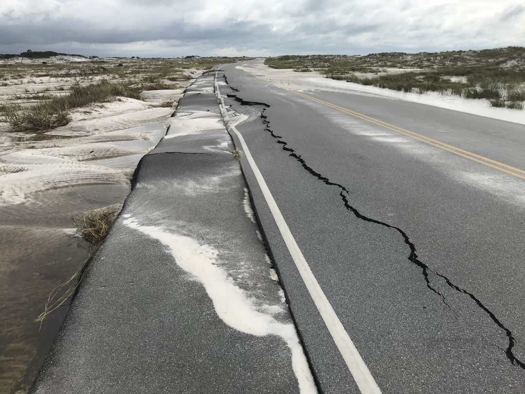
The edges of Highway 399 were also damaged in the storm, but most of it occurred in the bike lanes instead of the road itself. He said that's why the road was designed with attached bike lanes so they could be "sacrificial" to leave intact driving lanes.
Highway 399 is also one of two ways to drive off Pensacola Beach. The other, Bob Sikes Bridge into Gulf Breeze, was damaged during the storm as well but remains open, requiring cars to go just 5 mph to reduce vibrations.
"We recognize that that's an evacuation route and that's a way people can get off the island if one of the two (beach) bridges is damaged. We certainly recognize that," Brown said. "(Stoplights for the damaged section) works in other places but our observation of the use of that road is that it tends to invite people driving at very high speed and often times in the dark, under the influence so there's some concern there."
Madison Arnold can be reached at marnold@pnj.com and 850-435-8522.
tinyurlis.gdclck.ruulvis.netshrtco.de