Northwest Florida received the bulk of rain from Tropical Storm Marco, setting the record for rainfall on Monday in Pensacola, despite the storm officially making landfall in Louisiana.
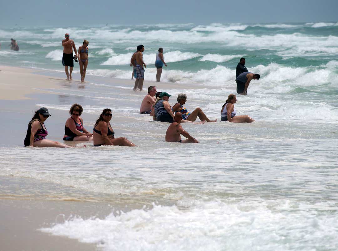
The lasting impact in the Florida Panhandle of Marco and Hurricane Laura as it approaches Louisiana and Texas will be high surf and dangerous rip currents along the coast.
Marco was torn apart by strong wind shear as it approached the Gulf Coast on Monday, sending most of its mass of rainstorms toward Florida while the core of the system with high winds moved northwest to make landfall near the mouth of the Mississippi River.
Pensacola was largely spared from the higher rainfall amounts from Marco seen in Apalachicola, where rainfall totals broke a record Sunday at 7.85 inches. But the 2.44 inches of rain Pensacola received as storms moved through Monday was enough to set a record for the rainfall total, according to Don Shepherd, meteorologist with the National Weather Service in Mobile, Alabama.
"It's still less than 3 inches, but for the day, it was a record," Shepherd said. "And that broke the old record, which was from 1961, and it was 2.16 inches."
Shepherd said much of the rain from Marco fell offshore before the storms moved over land, with NWS radar estimating more than 12 inches of rain falling offshore south of Fort Walton and Destin.
"It could have been just as easy that that foot of rain could have been over the Panhandle," Shepherd said. "We just lucked out that it was over the waters of the Gulf."
The largest dangers from Marco and Hurricane Laura remain strong rip currents and high surf, Shepherd said.
Live storm tracker: Hurricane Laura
Sea turtles: UWF team studying why so many sea turtles get hooked on fishing lines at Panhandle piers
The National Weather Service has a high surf advisory in effect for the Northwest Florida coast until 7 p.m. Wednesday. Waves heights were expected to increase throughout Tuesday into Wednesday, peaking at 6 to 8 feet overnight.
Dave Greenwood, Pensacola Beach water safety chief, said beach lifeguards rescued 28 people from the water Saturday in "moderate" surf from Marco, and on Sunday, red flags went up to keep people out of the dangerous water.
"We anticipate (the surf) starting to climb along higher into Wednesday as the storm gets closer toward the shoreline in the Gulf, so we anticipate red flags into tomorrow," Greenwood said Tuesday.
Greenwood said the red flags will stay up likely on Thursday, depending on the rip current hazards along the beach.
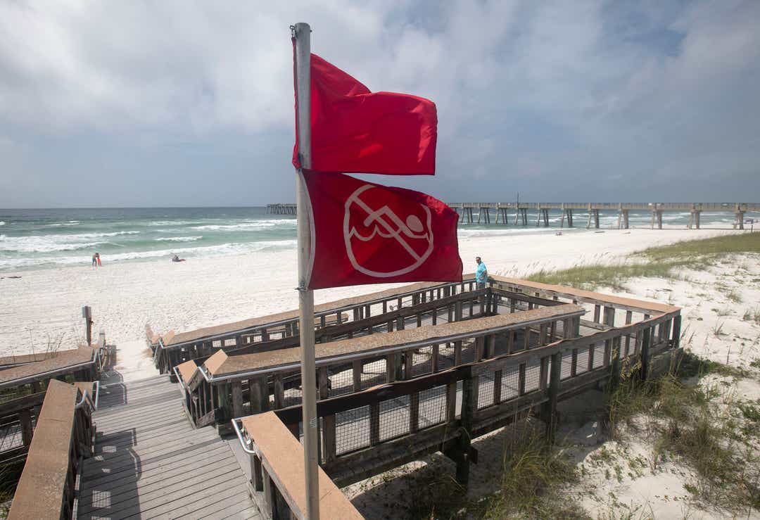
"It's dangerous surf, and we don't want people going in to where we have to put ourselves in peril sometimes to pull them out of the Gulf," Greenwood said.
Laura will likely be far enough away that the Pensacola area won't see much, if any rain, directly from the storm, but Shepherd said there will still be chances of scattered thunderstorms that are typical this time of year.
"So the rain chances will not completely go away here but the heavier rain potential will be ending," Shepherd said.
Jim Little can be reached at jwlittle@pnj.com and 850-208-9827.
tinyurlis.gdu.nuclck.ruulvis.netshrtco.de
مقالات مشابه
- <h1>راه حل افزایش فالوور اینستاگرام</h1>
- دسته بندی ابزارآلات
- تعمیرات تخصصی لوازم خانگی در کرج
- شرکت صادرات و واردات کالاهای مختلف از جمله کاشی و سرامیک و ارائه دهنده خدمات ترانزیت و بارگیری دریایی و ریلی و ترخیص کالا برای کشورهای مختلف از جمله روسیه و کشورهای حوزه cis و سایر نقاط جهان - بازرگانی علی قانعی
- اسباب بازی - آیا بعد مهم است؟
- روانشناسی اجتماعی (Ph. D. student سهام تحقیقات اساسی جهانی درآمد
- هدرز پژو XU7 رانر بلند HZ POWER
- شرکت صادرات و واردات کالاهای مختلف از جمله کاشی و سرامیک و ارائه دهنده خدمات ترانزیت و بارگیری دریایی و ریلی و ترخیص کالا برای کشورهای مختلف از جمله روسیه و کشورهای حوزه cis و سایر نقاط جهان - بازرگانی علی قانعی
- آناتومی مواد شیمیایی
- آموزش آنلاین نصب دوربین مدار بسته: راهی نوین برای یادگیری سریع و مؤثر