While hurricane season 2020 feels like it has gone on for between six months and three years already, the unfortunate truth is that 75% of hurricane season occurs in eight weeks of peak activity between now and mid-October. And, right on schedule, there are two threats to Florida and the U.S. Gulf Coast to monitor carefully over the next week.
An incipient uptick in activity starting around August 20 is not a surprise. As I mentioned last week, the early August lull was due to the storm-suppressing phase of upper-level winds known as the Madden-Julian Oscillation (MJO) over the Atlantic.
The good news is this MJO influence means the Atlantic is currently free of tropical depressions, tropical storms and hurricanes.
That is the extent of the good news.
These unfavorable winds are subsiding, and the storm-enhancing phase of the MJO will take its place for the next two to three weeks, coinciding with the climatological peak of Atlantic hurricane season on Sept. 10.
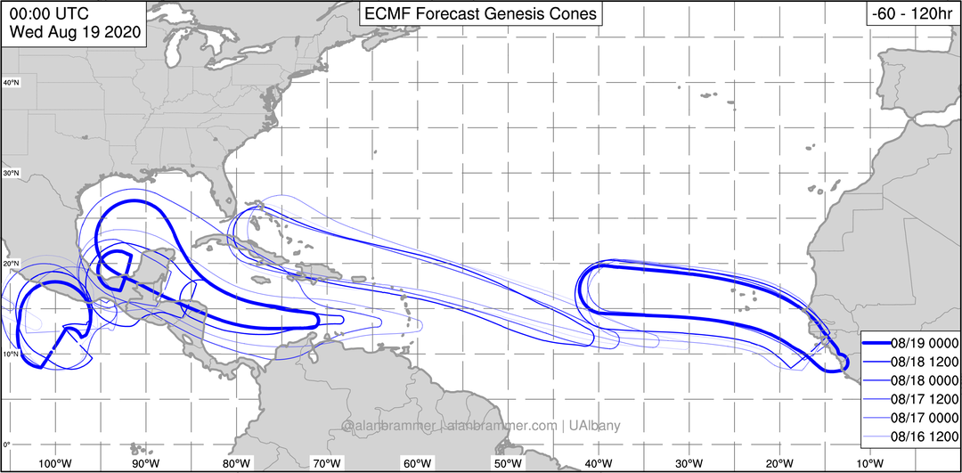
The first beneficiary of the power of MJOlnir is Invest 97L, a cluster of showers and storms currently moving west across the central Caribbean. Invest 97L became a little more concentrated southeast of Jamaica Wednesday, despite brisk shear to its north.
This disturbance will continue westward through Friday, before slowing and turning a little more northwestward near the Yucatan Peninsula on Saturday. Slowing down often triggers development of tropical waves, and a depression or tropical storm is likely by Saturday as shear lessens somewhat.
The second item up for bid is Invest 98L, located about halfway between west Africa and the Lesser Antilles. This tropical wave has also gotten better organized in the last day, and warm waters, low shear and ample moisture mean a tropical depression should form by Friday morning. Look for a tropical storm in the vicinity of Hispaniola by late Saturday.
Beyond this time, the future tracks and intensities of 97L and 98L are highly uncertain, made doubly so by the possibility they come close enough to influence one another. Models have been struggling mightily with these storms beyond the weekend, yielding long-range forecasts that are even more inconsistent than usual.
However, while models are less skilled in handling tropical development and intensification processes, they do much better with the jet stream patterns that determine the steering currents that storms follow.
A major reason for concern with these two systems is that all models agree on a risky steering pattern come early next week. There is a solid consensus for a potent high-pressure ridge centered between Bermuda and the Southeast U.S., and for a trough over the Ohio Valley and Deep South. Basically, the ridge keeps the storms moving westward until the trough then turns one or both northward near Florida or the Gulf Coast.
For 97L, a key to the forecast is speed of development. Faster development means the storm would feel the tug of the Ohio Valley trough earlier, and possibly threaten the central or western U.S. Gulf Coast in 5 to 6 days. A slower to develop and weaker storm would more likely continue west towards south Texas or the Mexican Gulf Coast.
Assuming 98L survives the ever-present threat of interaction with the highlands of Hispaniola and eastern Cuba, the environment looks favorable for intensification near the Bahamas.
See the models: Invests 97L and 98L are expected to develop soon. See spaghetti models here
Sea surface temperatures are nearly 90 degrees in places, and the trough may be set up to provide a favorable upper-level outflow channel to the north. Possible impacts in the Florida peninsula would be felt in 5 to 7 days, with a continuing threat to the Gulf Coast beyond that time.
There also is a third tropical wave in the far eastern Atlantic that has strong odds of development in the next week. As it will be riding west at a higher latitude than 97L or 98L, chances are higher that this system eventually turns north into the Atlantic. This feature should be watched over the next 10 days, starved for attention though it will likely be.
...tinyurlis.gdu.nuclck.ruulvis.netshrtco.de
مقالات مشابه
- توضیح تجهیزات پزشکی
- ایلنا
- شرکت صادرات و واردات کالاهای مختلف از جمله کاشی و سرامیک و ارائه دهنده خدمات ترانزیت و بارگیری دریایی و ریلی و ترخیص کالا برای کشورهای مختلف از جمله روسیه و کشورهای حوزه cis و سایر نقاط جهان - بازرگانی علی قانعی
- Pensacola مرد متهم به ضرب و جرح زن هدف قرار دادن کودک در صورت
- چگونه می توان عملیات را ساده کرد و هزینه ها را از طریق بودجه بندی موثر کاهش داد
- شرکت صادرات و واردات کالاهای مختلف از جمله کاشی و سرامیک و ارائه دهنده خدمات ترانزیت و بارگیری دریایی و ریلی و ترخیص کالا برای کشورهای مختلف از جمله روسیه و کشورهای حوزه cis و سایر نقاط جهان - بازرگانی علی قانعی
- روغن هیدرولیک
- کسب و کار پر رونق می خواهید؟ از استخر بادی اجتناب کنید!
- Downtown residence offers a fabulous water view, high-end amenities and privacy | Hot Property
- شرکت صادرات و واردات کالاهای مختلف از جمله کاشی و سرامیک و ارائه دهنده خدمات ترانزیت و بارگیری دریایی و ریلی و ترخیص کالا برای کشورهای مختلف از جمله روسیه و کشورهای حوزه cis و سایر نقاط جهان - بازرگانی علی قانعی